Blog: Three trends shaping the future of road imagery
Keith Anderson, Marketing Manager
The way roadway imagery is used is changing. In our first 15 years aggregating and providing imagery from road-facing cameras, there wasn’t a single organization using our camera feeds for automated analysis. Now over 70% of our new business uses our road imagery, from both connected on-vehicle cameras and roadside traffic cameras, to automatically pull insights about traffic volume, weather conditions, road infrastructure, or other safety concerns.
Historically, our customers mainly fall into 5 categories: broadcast media, traffic apps, fleet dispatch, operations centers, and automotive. All of these use cases involve either end users, operators, or presenters manually reviewing available camera feeds on a map interface and interpreting potential road condition impacts on drivers. Although we still serve customers in all of these industries (we’ve averaged just 1% annual customer churn over the past decade), it’s obvious something new is happening. I see 3 contributing factors:
1. More data has created a need for automation
Blame smartphones, IoT devices, AR/VR product developments, higher bandwidth availability due to 5G, or the steady march of Moore’s law – whatever the cause, cameras are becoming smaller, cheaper, higher resolution, more connected, and bandwidth is more available. Cameras have always been one of the richest sensors and the decreasing cost of bandwidth is finally unlocking the full potential of imagery.
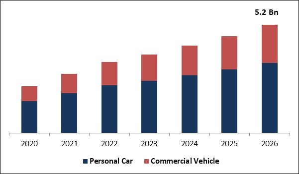
Global Dashboard Camera Market Size forecast from KBV Research
Take this technological capability and add in the fact that insurance costs are skyrocketing, and this is the perfect recipe for an explosion of connected vehicle cameras. Vizzion’s on-vehicle camera network has grown by approximately 16x since its launch, we now access about 40 Billion total images per month from our camera network. This is more content to review than is feasible by any team of people, but automated analysis of these images – even if not yet perfected – can decimate the workload and help serve relevant and timely insights to the right people. With skilled labor shortages, this is more important than ever.
We’re also seeing cameras working their way into other new vantage points. Autonomous vehicles have cameras on every side and surface, while DOTs are using drones in addition to their roadside traffic cameras. Two of our latest projects involve ground truth verification of data from satellites – including smaller and cheaper micro satellites.
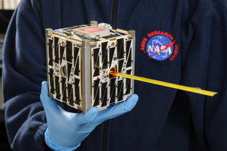
Micro Satellite developed by NASA
2. Proliferation of AI capabilities
For years now, colleges have been preparing their students for this eventuality by including computer vision and machine learning as part of their comp science curriculums, so we’re now seeing engineers with this experience coming right out of school, and they’re taking advantage of excellent out-of-the-box tools. We’ve done some experimentation with ML.NET and found the models produced can often out-perform traditional computer vision algorithms by an order of magnitude in terms of accuracy. The availability, variety, and size of training sets have improved too; Vizzion is playing a role here as well by now offering labeled image sets to help our partners get to a productive model quicker.
Ready to use labeled data sets can cut down AI development time by months
3. New use cases, primarily led by autonomous driving
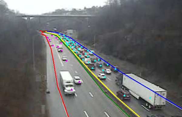
Improvements in sensors and AI are advancing long-promised fully autonomous driving, which in turn is creating additional camera and AI requirements. Autonomous vehicles need to know where to drive, which is currently accomplished through high definition lidar maps, but they also need to know where it is safe to drive. A road that is under construction is not safe for an autonomous vehicle and even after roadwork is complete, that stretch of highway will likely need to be re-mapped with lidar. Our imagery helps HD map providers determine when a stretch of road is under construction and when it’s ready to be re-mapped so autonomous vehicles can travel safely again. In parallel to this, another one of our partners processes our road imagery to alert Departments of Transportation to any potential issues in their road network that, for example, may hinder ADAS services (e.g. faded line paint, damaged infrastructure, vegetation).
Fading line paint can cause issues for autonomous vehicles
In a world already built for visual navigation, cameras are the best sensor to help us transition from human decision making to automation. This is one of the reasons why Tesla has gone entirely camera-based for their ADAS features. This single sensor can not only read signage but also tell you if the road conditions are improving or worsening, or even if a parking spot is open. Another key benefit of image-based intelligence that isn’t as flashy or widely discussed is the ability to perform a root-cause analysis and understand what exactly happened if something goes wrong. This allows for iterative improvements in safety and also allows other visual and “official” use cases that may require a paper trail like insurance claims investigation, evidence in a court of law, driver behavior, and security reports.

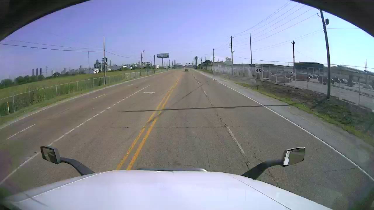
Roadwork closing an off-ramp, making autonomous navigation difficult, captured by Vizzion’s camera network.
It's a time of change and we’re taking this opportunity to do feasibility studies with partners on several new use cases, but I bet we’re only scratching the surface. If you have an idea or a problem that might be solved with road imagery and automated insights, reach out and let’s talk. With cameras mounted on every side of new vehicles, plus roadside infrastructure, drones, and satellites, combined with automated insights for safety and convenience, and instant V2V/V2I communication, imagine what the next 15 years could look like.
About Vizzion
Vizzion is the leading provider of road imagery for traffic, weather, road condition, and safety operations and applications. Through partnerships with over 200 different transport agencies and on-vehicle camera providers, Vizzion offers live feeds from over 100,000 cameras in 30+ countries. Both on-vehicle and roadside traffic camera services are available through Vizzion’s flexible API and turnkey Video Wall application. Vizzion’s content is trusted by major apps, map providers, broadcasters, fleets, and automotive organizations. Contact busdev@vizzion.com for more information.